KLS improves client's assest management practices by using a system that relates assets through maps
and intelligent location processing. KLS staff integrates GIS with geographic
asset management systems that allow agencies to manage, visualize, analyze, and communicate
information about infrastructure assets such as traffic signs, sidewalks, roads, bridges, etc.
Also, linking GIS to a pavement management system provides an efficient means to query data and
display trends and patterns to track pavement condition and allocate funds effectively.
KLS integrates diverse data (e.g. existing conditions, accident histories, economic needs,
hazardous materials shipment and vehicle volumes) with accurate locations. Infrastructure
asset data (asset type, dimensions, exact location) also can be collected. Once integrated, this
data can be modified and presented both in raw and processed format, according to user needs.
KLS is also an adviser to the TRB Committee on Geo-Spatial Data. Sample Projects include:
-
Developing an Asset Management Framework for Interstate Highway Safety, NCHRP Project.
-
ADA Asset Management.
-
School Safety Asset Management, DDOT.
-
Street Lighting Inventory, DDOT.
-
Georgetown Traffic Control Device Inventory, DDOT.
|

|
|
Georgetown Transportation Study
|
|
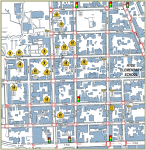
KLS conducted detailed Sign Inventory and GIS mapping for the Georgetown
Transportation Study. This was an essential tool for site analysis and developing mitigating measures.
|

|
|
Asset Management Framework
|
|
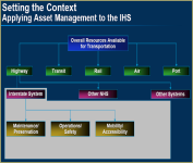
KLS was part of the (NCHRP) Project 20-74 team that developed a practical framework for applying asset management
principles and practices to managing Interstate Highway System investments.
|

|
|
DDOT Street Lighting Program
|
|
KLS provides support to DDOT Street Lighting Branch in QA/QC inspections, and asset validation. KLS also
provides night time inspections to verify the accuracy of work order completion,
as well as assess other system deficiencies.
|
|